Filter By:
Maps
$16.99
Designed for Hike, bike, horse, motorized, public lands, camping & more...
Printed on waterproof & tear resistant paper for rugged toughness!
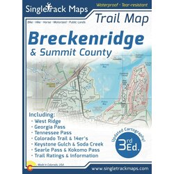
?Map Details:
Trail Information and Ratings: Easy, Medium, Difficult
Scale 1:46,250 - 1in = 0.73 Miles or 1in = 1.17 Kilometers
Detailed Contour Lines. Contour Interval = 40ft
Measures 4” x 5.5” folded and 36” x 22” fully open
3rd Edition - Printed in July 2021
Map Includes:
?West Ridge
Georgia Pass?
Jefferson Creek Trail
Kenosha section of the CT
Colorado Trail
Soda Creek
Keystone Ranch
Frisco Peninsula
Eagles Nest Wilderness
Copper Mountain
Searle / Kokomo
Camp Hale
Tennessee Pass
Fremont Pass
14ers like Mt. Democrat
Cameron, Lincoln, Bross
Climax
Tenmile Range
Breckenridge
French Gulch
Gold Dust Trail
Como
and much more!
Also Includes;
Trail Mileage
Detailed Roads
Campground Information
Public Land Boundaries
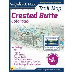
$16.99
Printed on waterproof & tear resistant paper for rugged toughness!
Map Details:
Trail Information and Ratings: Easy, Medium, Difficult
Scale 1:60,000 - 1in = 0.95 Miles or 1in = 1.5 Kilometers
Detailed Contour Lines. Contour Interval = 50ft
Measures 4” x 5.5” folded and 36” x 22” fully open
5th Edition - Printed in October 2021
Field Checked & Accurate!
Field checked cartography for the most accurate and up-to-date map available! We don’t rely on other parties for our data, we get outside and collect our own trail and geographic data.
Map Includes:
Lupine Trail
Baxter Gulch Trail
Gunsight Connector Trail
401 Trail
Snodgrass Trail?
Upper & Upper Upper Trails
Lower & Upper Lower Trails
CB Mountain Resort Trails
Raggeds Wilderness Area
Green Lake Trail
The Dyke Trail
Deer Creek Trail
Strand Hill Trails
Brush Creek Trail & Star Pass
Teocalli
Reno/Flag/Bear/Deadman
Spring Creek Canyon
Doctor Park Trail
See the Whole Picture
Stop staring at that tiny phone screen & see the entire landscape in one glance on this map! Beautiful and accurate cartography gives you the "big picture" view without having to scroll around on a 4" digital screen.
Local
Made in Colorado! From the cartography to the final printing. Every step takes place in Colorado. Buy Local!
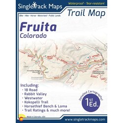
Printed on waterproof & tear resistant paper for rugged toughness!
Map Details:
Trail Information and Ratings: Easy, Medium, Difficult
Detailed Contour Lines.
Measures 4” x 5.5” folded and 16” x 22” fully open
1st Edition - Printed in March 2018
Field Checked & Accurate!
Field checked cartography for the most accurate and up-to-date map available! We don’t rely on other parties for our data, we get outside and collect our own trail and geographic data.
Map Includes:
18 Road trails
Kokopelli loops
Horsethief area
Loma
Mack Ridge
Hawkeye Trail
Rabbit Valley
Westwater
Zion Curtain
Area Reference Map
See the Whole Picture
Stop staring at that tiny phone screen & see the entire landscape in one glance on this map! Beautiful and accurate cartography gives you the "big picture" view without having to scroll around on a 4" digital screen.
Local
Made in Colorado! From the cartography to the final printing. Every step takes place in Colorado. Buy Local!
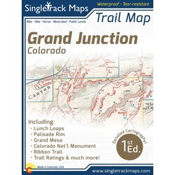
Printed on waterproof & tear resistant paper for rugged toughness!
Map Details:
Trail Information and Ratings: Easy, Medium, Difficult
Detailed Contour Lines.
Measures 4” x 5.5” folded and 16” x 22” fully open
1st Edition - Printed in March 2018
Field Checked & Accurate!
Field checked cartography for the most accurate and up-to-date map available! We don’t rely on other parties for our data, we get outside and collect our own trail and geographic data.
*Please note that this 1st Edition maps does NOT show The Palisade Plunge.
Map Includes:
Lunch Loops
The Ribbon Trail
Third Flats
Gunny Loop
Butterknife Trail
Colorado National Monument
Palisade Rim Trail
Grand Mesa
See the Whole Picture
Stop staring at that tiny phone screen & see the entire landscape in one glance on this map! Beautiful and accurate cartography gives you the "big picture" view without having to scroll around on a 4" digital screen.
Local
Made in Colorado! From the cartography to the final printing. Every step takes place in Colorado. Buy Local!
Printed on waterproof & tear resistant paper for rugged toughness!
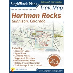
Map Details:
Trail Information and Ratings: Easy, Medium, Difficult
Detailed Contour Lines.
Measures 4” x 5.5” folded and 16” x 22” fully open
2nd Edition - Printed in March 2018
Field Checked & Accurate!
Field checked cartography for the most accurate and up-to-date map available! We don’t rely on other parties for our data, we get outside and collect our own trail and geographic data.
The Hartman Rocks Recreation Area is located directly south of Gunnison in the Central Colorado Rockies. This area is a mecca for all types of recreation and is still one of Colorado’s last hidden gems! If you’ve always just passed through Gunnsion on your way to the world-renowned trails in Crested Butte do yourself a favor and stop to ride at Hartman Rocks. This trail system absolutely ROCKS!
Map Includes:
Trail mileage
Road mileage
Trail difficulty ratings
Recommended Rides
BLM Climbing Areas located and labeled
Areas adjacent to WSCU Campus
See the Whole Picture
Stop staring at that tiny phone screen & see the entire landscape in one glance on this map! Beautiful and accurate cartography gives you the "big picture" view without having to scroll around on a 4" digital screen.
Local
Made in Colorado! From the cartography to the final printing. Every step takes place in Colorado. Buy Local!
Page 1 of 1